Some circumstances made decision a bit clearer - I probably will start my trip in December or February.
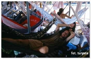
I was cruising on a river cargo boat on the Brazilian Amazon. I was rocking in a hammock, when suddenly in the middle of the night we stopped and hauled on board a white man. The story of this Swiss guy very intrigued me – he bought a rowing boat and was running down the Amazon for several weeks. When he got bored, he sold the boat and now caught a ride on our boat. He even didn’t have a Brazilian passport stamp, just some piece of paper from a policeman living close to Brazil-Ecuador border. I was impressed. Even more, he just showed me by his own example that you can go beyond the standards, you can do things your own way, just what you want. After this conversation, I could not sleep. I took a notebook and drew a map of South America. I decided that one day I set up to cross this continent without any motor engine. I looked at the map and had the plan - from the South to the North Cape. It was April 15, 2004.
I've never forgotten that night, the first moments of “PLAN - Unmotorized South America Adventure”. However, since then, my life has changed. First of all I met my other half soul, got married, and we decided to spend the next travels together (Africa 2007, Central Asia 2009). After I got fascinated with the deserts and the desert cart construction cost me a bit work and money. But I never abandoned my dream of “PLAN - Unmotorized South America Adventure”. I slowly gathered information, I researched, I met up with travellers, I asked,  I collected maps and the equipment. My "dream trip" has lived in me all this time. Sometimes it seems to me that this adventure is beyond my physical capacity, it’s too difficult. But when I read the book of great explorers (eg, Horn, Nowak, Muir), when I watch movies for eg. about refugees escaping from Siberia, I realize that my trip is just a holiday excursion. Then I feel that I am almost ready and it’s time for me.
I will give some more details of the adventure. Since I have a lot of unknowns, please share the information or give me a contact to people, who can give me some hints.
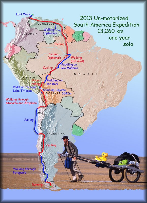
Adventure will start at the most southern end of mainland South America, the Chilean Cape Froward (Cape Horn is located on the island). Using unmotorized means of transport, such as legs, bike, horse, paddling boat, sailing, hang-gliding, etc., I plan to reach the most northern tip of the mainland continent, Colombian Cape Gallinas. To cover this over 13,260 km, 13 months should be enough.
I’m preparing very carefully for the first part of the journey - Chile, Argentina and part of Bolivia. Here, I have good maps and a lot of information on the internet. Later, however, it’s a bit worse, so I will improvise on the spot. Perhaps this arrangement is also exciting.

General idea of the adventure:
1. Running from the most southern point in mainland Chile (Cape Froward) to Puerto Natales - distance 350 km, approximately pace 30-50 km per day, duration 10 days.
2. Hiking through Andes up to Puerto Montt (or around 41° S where Chilean Patagonia is finished) - distance 1960 km, approximately pace 20-35 km per day, duration two months and three weeks.
3. Cycling to the Aconcagua base camp, then continue by bike to the coast - distance 1775 km, approximately pace 60-100 km per day, duration three weeks.
4. From the coast (Vina del Mar or Valparaiso) hitchhiking on a sailboat to Antofagasta - distance 1100 km, duration two weeks.
5. Here by foot pulling my 2-wheel desert cart through Atacama Desert in Chile (via San Pedro de Atacama), Altiplano in Bolivia (climbing Sajama 6542m), until Lake Titicaca (Copacabana) - distance 1370 km, approximately pace 20-25 km per day, duration two months.
6. Crossing the Lake Titicaca on paddling boat - distance 32 km, duration two days.
7. Horse riding across Andes, from Lake Titicaca Coast to Rurrenabaque (via Apolo) - distance 505 km, approximately pace 15-25 km per day, duration four weeks.
8. Now the most difficult thing, because I do not have enough experience - Amazon Jungle. Paddling on Rio Beni – estimated distance 830 km, pace 30-35 km/day, duration four weeks.
9. Cycling from Riberalta to Porto Velho – estimated distance 425 km, pace 75 km/day, duration one week.
Then paddle on Rio Madeira until Brazilian village of Borba (south of Manaus) – estimated distance 880 km, pace 30-35 km/day, duration four weeks.
Optional - walking with the guide through the jungle to Manaus - distance 200 km, approximately pace 10-20 km per day, duration two weeks.
10. Cycling to Roraima in Venezuela - distance 1015 km, approximately pace 75-100 km per day, duration two weeks
11. Optional - maybe I can use hang gliding for a short distance. Later if I find a guide and would have enough strength to walk, I will hike towards Angelo Falls (the highest waterfall in the world), and then return north to civilization (around Ciudad Bolivar) - distance 860 km, approximately pace 20-25 km per day, duration five weeks.
12. Cycling by bicycle through Venezuela to Colombia - distance 1260 km, approximately pace 75-100 km per day, duration three weeks.
13. The last part is to walk from Maicao town to the most northern point of mainland continent of South America (Cape Gallinas) - distance 180 km, approximately pace 25 km per day, duration one week.