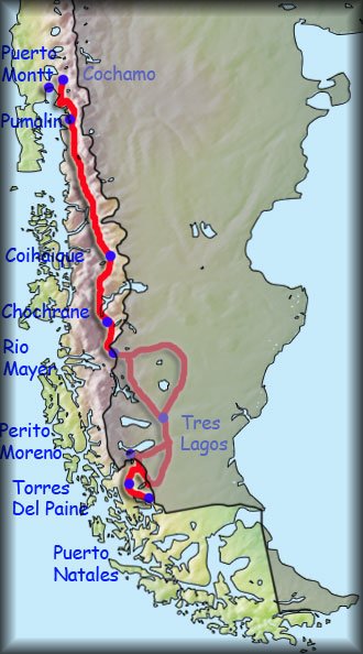
Hiking through Andes up to Cochamo (near Puerto Montt, where Chilean Patagonia is finished) - distance 1960 km, approximately pace 20-35 km per day, duration two months and three weeks.
 Chile is a relatively civilized country. Nevertheless, at this stage of the journey I have many unsolved cases. I could choose the easier route along the Argentina Ruta 40, but I want to see the most beautiful part of Patagonia. In Puerto Natales I’ll collect my main luggage with all necessary survival equipment (looking for a contact to deposit it). As for the running stage I will take only a total minimum. Also when arriving from Santiago to Punta Arenas, I'll drop off containers with freeze-dried food (lighter weight). Since a large part of my plan is to hike away from the roads, food drop offs won’t be too frequent.
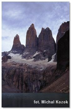
At the beginning I go to the Torres del Paine NP. Arriving from the south-west I’ll begin the “W” track. I won’t miss of course the famous three towers (Tres Torres) which I have had the pleasure seeing a few years ago.
From Torres del Paine path leads straight to Argentina (Verlika Pass). Unfortunately it isn’t accessible for tourists. After all, I’ll apply for government permit, I'm already on preliminary discussions with the Chilean border guards.
Option 1 - if I succeed, I will have a shorter and wild path.
Option 2 - if the permission for the hiking from Torres del Paine to Los Glaciares will be denied, then I will have to make detour and of 125 km, cross the border for cars in Cerro Castillo (on which pedestrians might not be allowed, so I'll have to borrow? a bike for 7km!).
In any event, all three options end up in the area of Argentinean town El Calafate. Hence I take a "shortcut" through Argentinean Pampa, walking via Estancia Federica (road No 31) to road No 81. But I need a good map to prepare for this walk (maps might be available for purchase in Buenos Aires, but not online). In any case, I would like to get to the border on the Rio Mayer.
 According to info on the internet, few people use this border crossing. The reason is simple - lack of public transport, many unmarked path intersections, the lack of villages on the route, and most importantly, it’s impossible to cross this border for 2WD cars. Not only that, after bridge collapsed (2009), there is also no possibility to cross the border with dry feet. The bridge was privet, used by sheep, and now no one has need to fix it. Despite all border services are on duty, and passport can be stamped there. Anyway, there is a small problem of crossing the mountain Rio Mayer . One online forum guy sent me the pictures and description of it, but it doesn’t seem easy task. Particularly it’s much more difficult to cross it in the summer, when the glaciers melt and the river is more turbulent. But I came up with an idea that while driving a car south from Santiago, I’ll bring a simple inexpensive inflatable rubber boat. I would like to deposit it for several weeks to Argentinean border guards. When I get there I will stamp my passport and look for a peaceful stretch of the river, using the rubber boat to cross Rio Mayer. There, I’ll offer the boat to Chilean customs officers, or just abandon it.
After crossing the border on the Rio Mayer there is just around 40 km to Villa O'Higgins. But I'm not going there because I found on Google Earth and my topographic map possible “shortcut”. As it usually happens with shortcuts, they are not the fastest option. In this case, however, it can be a very interesting track. I have not found any information on the internet, so that crossing the Andes mountains along the border with Argentina could be extremely interesting (near Cerro Lorenzo). There is a stretch all the way to Cochrane with total wilderness (150 km), I hope this area will be passable. Topographic maps don’t show vertical cliffs and glaciers all the way, so there will be some way to get through.
In Chochrane I will collect my food resupplies and I'll follow along the road No. 7. In Cerro Castillo (same name but different village then border crossing) area I'm going to take a mountain trail hiking. However, this part is an officially accessible by park authorities, you pay and you can go on the trail. However, it is very rarely used.
From Coihaique to Chaiten I'll follow along the road No. 7, with small side trips at the most beautiful places. One of them will be Quelat National Park, but I have not figured yet what to see over there..
 In Chaiten the hardest part of Patagonia waiting for me. On my way there is in fact a private park Pumalin. It is huge, and only with a few hiking trails. Recently Chaiten volcano erupted, and the park was closed for two years. In 2010/11 re-opened. The Chaiten I would pick up (I do not have contact yet) previously deposited resupplies of light freeze-dried food. Unfortunately the park owner, the founder of The North Face, Doug Tompkins, had refused me crossing the park on foot. I'm looking for contacts of people who could hire me sea kayak to cross this fjord.
After defeating Pumalin, I need to get to Cochamo via Park Hornopiren, where I would pick up my cycling equipment (I do not have contact yet).