Entry twice, first 12.09 in Drakensberg, second 17.09 till 26.09.07, in total 10 days, currency rate 1€ = 9.4 L (Loti)
 highlights – from Swaziland we entered South Africa (describe in South Africa), and later on we got to Lesotho. First time accidentally walking in the mountains, and second time officially crossed the border.
In Rome we went to see "the dinosaur's footprints" in the rock behind the village. You do not need a guide there - just ask the locals. This is not the object you necessary must see, unless someone hasn't seen any remains of those prehistoric creatures.
In Lesotho very popular is "Pony trek", especially in Malealea village, then in Semonkong. In the north Molumong near Mekhotlong, where you can even go on several days trip including climbing the highest peak of Southern Africa - by horse! We got to Semokong and took the organize excursion with local guides. Prices vary depending on the number of people willing do the same trip, the more people the cheaper, including a horse for you, baggage horse and guide, accommodation in local village with access to gas stoves. You have to take your sleeping bag, food (cheaper if you bring it from the capital), warm clothes and waterproof shell if you're travelling in summer.
Sample prices f the same trip or the trip per person - 1 night (2-days) 730 L, 2 nights for 1410 L, every next night about 500 L more. Now price per person for the same trip but when two people willing do a tour: 1 night 590 L, 2 nights 895 L and then about 300 L for each extra night. Price per person when 3 people want to go: 1 night 510 L, 2 nights 775 L and every next one approximately 260 L. One day trek (without accommodation and baggage horse) also depends on the number of people and costs 210 L per person, or 165 L / person when two people go, 145 L / person with 3 persons. It's organized here the longest commercial single drop abseil along the Maletsunyane Falls (204M, minimum 2 days course, from 750 L / person to 600 L / person when three people). I do not need to mention that the guide is expected the tip.
Brave horses carried us on their backs on narrow mountain paths at altitudes close to 3,000 meters. Sometimes the track was so steep (both uphill and downhill), that I was waiting with fear when a horse fall down. Although the hooves were slipping on the smooth stones, the horse was confident and was going on forward - I am full of respect for them. Only once my pony didn't listen - during the river crossing he drunk the water and after desired to take a bath - he gave me a second to get off and fall dawn in deeper water. Fortunately the camera was on Ewelina's horse.
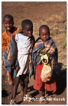
Region where we travelled was wonderful - dry and open space, mountain ranges and deep valleys, canyons, gorges, waterfalls. For accommodation we stopped in a small village, where life still goes on in its old primitive style. Round stone houses, straw roofs, the floor made from soil mixture with animal droppings. The unique atmosphere made also candles, fireplace, goat flock, barefoot kids, and the elderly covered by merino wool blanket during morning frost and cold night. During riding everything was ok except the first hours of the second day when we felt the painful buttocks and some of the leg muscles - we did too much trot the day before (the first day in the saddle 5h, approximately 14 km). Fortunately our fears about commercial character of this trip have been not confirmed, mainly through the friendly attitude of locals. In Ketane you might take a 20-minute walk to Ketane Falls 122m - a good view from the top. We asked our guide to take us into someone's home, it was interesting to see how locals really live. The houses are interesting flagged - white flag means that you can buy there homemade beer, the green flag - vegetables, and red - the meat. On the way back we went over the Maletsunyane waterfall (204M), which is interesting scenery, but in the dry season did not contain much water. At noon the sun shines from opposite side, so you can get better photo shot out of the midday. You can also walk downhill to the base of the waterfall (there is a camping site), this shouldn't take more than 40 minutes, a bit longer uphill of course. There is only one hour riding to Semonkong.
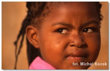 After a pony trek we back to the lowlands, where again local people straight invite us from the street to warm hospitality in their houses. I was only a little frustrated then as usual I wanted to help the local economy by buying on the markets or small shops, but almost all shops here, even the small one, were managed by uncongenial Chinese. After a few days we came back to the "Mountain Kingdom" but this time we were carrying our stuff. We reached the Sani Pass (2865 m), where is the only in the country west road link with South Africa (only by 4x4 cars, but also allowed are local public minibuses). It is a small village on the cliff, with one hotel divided to a luxurious part with restaurant and a budget part with kitchen to use and hot shower only between 6 to 10 pm. In addition there were two poorly supplied local shops. It is worth to wake up at sunrise, especially when the sun comes out over the clouds located in the valley under the cliff. Before we left, I went to the highest Southern Africa peak - Thabana Ntlenyana, 3,482 m above sea level. The only people who I had the pleasure to meet during the trekking were single shepherds with their sheep and dogs. They were covered by blankets and looked wild, but always smiling and even happy to get involved in the short conversation, usually based on gestures. The wool blanket in addition to thermal function, is also providing a symbol of status in society. From the summit I looked at the world below me, although I haven't seen much because the clouds covered all area below the escarpment. As I noticed later the entire trekking duration I was in the sunny place, and waiting for me Ewelina in Sani Pass had dense fog since morning.
 To get to the summit you can take a walking or riding tour with guide for 150 Loti/Rand (8-9 hours). Here are the way guidelines from Sani Top Chalet (2873m) to the peak of Thabana Ntlenyana, duration 4 hours one way, distance 12 km one way. Getting started in a North-West direction and slightly traverse the ridge on the right. After about 1 hour we have a last look at the Sani Top and we cross the ridge and start slightly walking downhill towards East. We have a valley in front of us, and on opposite side (north) there are two river streams. Walk downwards in a northerly direction (about 25 min) and select the second river bed (eastern one), which will be your way to climb up. Do not aim the highest point, but on the north-east side its lowest point (pass) - from here towards the north we see the next range runs east-west. It is already possible to see the highest peak in Southern Africa, look at north and slightly east. Walk steeply downhill, cross the river and climb uphill on the left slope of the mountain. Come to the plateau and still you have 15 minutes to the north, when you can clearly see the highest mountain in Africa south from Kilimanjaro. From the top of Thabana-Ntlenyana (3482m) towards the east you can see the cliff, and below it the South Africa. If visibility is good enough I suggest go back on the edge of escarpment and follow along it in the south
  direction. This is longer, but beautiful. The first valley you cross almost without decent, but the next valley you must move a bit away from the cliff, go long way down and after crossing the river to climb steeply towards the south, choose the pass a bit on west side. Now downhill in the south-west direction to Sani Top, but in my case, the whole valley was flooded with the mist and I could not locate the village. Fortunately cliff is the natural border from the east and from the west and north the unpaved road - no way to be lost. From the summit to Sani Pass including the photo session and meetings with locals took me 4.5 hours. Shepherds often agreed to take a free photos, and I usually share my lunch with them.
| town | site | price in L | €/ pp | duration | price | comments |
| Semakong | pony trek | 590 L | €62.8 | 2 days | worth | guide, horse per person, horse for luggage, accommodation |
| tip | 50 L/ 2 persons | €2.7 | - | - | tip for guide | |
| €65.5 |
![]()
 accommodation – unfortunately it is not so cheap. We couldn't find anything cheaper then 200 L per room at the first night in Hlotse. Fortunately from the parking took us one of supermarket employee and had offered us the accommodation at his mother house. He took a little bit money but he was a good company and it was a very interesting experience.
The problem to find a cheap accommodation also appeared in Mokhotlong, where according to the Lonely Planet the cheapest hostel should be Grow - dormitory cost 70 L and anyway there were no vacancies. At the east end of the town is a school called FTC, and on weekend there was no students and full of vacant rooms.
At the Sani Top Pass you can rent the chalet for a few hundred rands (or Loti). Just few hundred meters away there is a separate building for backpackers, a dormitory for 100 L, however, we decided to sleep in tent for half of that price, but because was raining we spent the night on mattresses in the kitchen.
| town | hotel and address | N | accommodation | price per night | €/ pp | note | comments |
| Hlotse | hospitality | 1 | house | 15 L/ per | €1.6 | ||
| Roma | Trading Post GH, LP | 1 | tent | 55 L/ per | €5.9 | 6 | kitchen |
| Semokong | Semokong Lodge, LP | 1 | tent | 50 L/ per | €5.3 | 7 | kitchen |
| Catholic Mission | 1 | room | 50*L/ per | €5.3 | 5 | normally 70 L, no water, dirty | |
| Katane | hut in village | 1 | mattress | cost in highlights | 4 | gas, stove and pots | |
| Mokhotlong | FTC, 2km east from the centre |
1 | room | 50 L/ per | €5.3 | 6 | gas and stove |
| Sani Top | Sani Top Chalet, LP | 2 | kitchen | 50 L/ per | €5.3 | 7 | tent 50 L/ person, dormitory 100 L/ person |
| in wild | 1 | tent | |||||
| hospitality | 1 | tent | |||||
| 10 | €34.0 (8) | ||||||
![]()
 transport – we had two tactical errors in terms of the travelling in Lesotho. We didn't know that from Samonkong you can't continue the drive to the east (unless by horse), you must return the same way to Roma. Here again we got the wrong information, because from Roma we could travel to the east, to Thaba Tseka, because then there is a connection to Mokhotlong. And we without this knowledge travelled twice the same way via Buthe-Buthe.
| day | destination | transport | price in L | €/ pp | duration | km |
| 249 | SA border - Butha-Buthe | shuttle taxi | 3 L/ person | €0.3 | 15' | 5 |
| 249 | Butha-Buthe - Hlotse | minibus | 5*L | €0.5 | 30' | 35 |
| 250 | Hlotse - Maseru | 2x minibus | 26 L | €2.8 | 1,5 h | 93 |
| 250 | Maseru - Roma | minibus | 10 L | €1.1 | 1 h | 30 |
| 251 | Roma - Semonkong | bus | 17 L | €1.8 | 3 h | 100 |
| 252-253 | Semonkong - Katsane - Semonkong | horse | cost in highlights | 2 days | 24 | |
| 254 | Semonkong - Maseru | pick-up | - | - | 3 h | 130 |
| 254 | Maseru - Butha-Buthe | 2x minibus + hitchhiking | 29 L | €3.1 | 3 h | 128 |
| 255 | Butha-Buthe - Mokhotlong | minibus | 60 L | €6.4 | 4 h | 170 |
| 256 | Mokhotlong - Sani Top | 2x hitchhiking | - | - | 2 h | 60 |
| city transport | shuttle taxi, minibus | 8 L/ person | €0.9 | - | - | |
| €16.9 | 775 | |||||
![]()
visa – in some point in our journey through Africa we got the ambition to cross the continent without a bribe - this was not easy, but we could manage so far. Only a few nations of the European Union still need visa to Lesotho and Poland is one of them, and what is worse, in the consulate in Durban it costs 54 €. So we chose the small border crossing and tried our luck with our new EU passports (as we did in the Gambia), or enter without a visa and later purchase it within the country (as in Malawi). Unfortunately, to our surprise, the official said "problem". Explanations didn't help - officer in the gesture clearly let us know what choice we have. We had two options - come back by hitchhiking to other border and see what happened there or either.... well, general fatigue due to hitchhiking we decided to put the 50 rands bill into our passports (5 € each). Officer with smile issued a visa for 10 days.
Lesotho has representation in South Africa. In Europe you must contact the Great Britain embassy.